Maps have been a crucial tool for understanding and navigating the world throughout history. Some of the oldest known ones offer fascinating glimpses into how ancient civilizations perceived their surroundings and charted their knowledge. From guiding expeditions to illustrating entire worldviews, these reflect both practical needs and cultural beliefs. Each one tells a unique story about the era and society that created it. Below, we explore some of the most remarkable and ancient maps, highlighting their origins, creators, and the geographical knowledge they preserved.
Fra Mauro Map

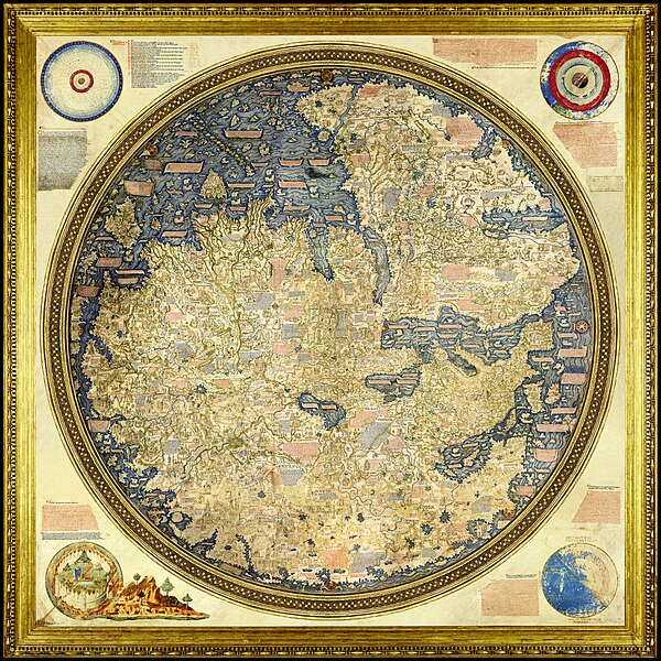
Completed around 1450 CE by the Venetian monk Fra Mauro, the Fra Mauro map is considered one of the greatest achievements of medieval cartography. This circular planisphere, drawn on parchment and set in a wooden frame, measures over two meters in diameter. Oriented with the south at the top, it depicts Europe, Asia, Africa, and the Atlantic, incorporating information from travelers and explorers. It is richly detailed, featuring numerous illustrations and over 3,000 descriptive texts. His work marked a departure from traditional medieval maps by not placing Jerusalem at the center and by focusing on empirical observations. His map reflects the growing influence of exploration and trade during the Renaissance. Today, it remains an invaluable source for understanding the medieval worldview and the transition toward modern cartography.
Kangnido Map

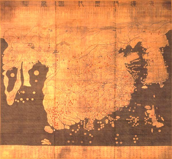
The Kangnido map, officially titled “Honil Gangni Yeokdae Gukdo Ji Do,” was created in Korea in 1402 CE. It is one of the oldest surviving world maps from East Asia, reflecting the geographical knowledge of the time. The map was a collaborative effort by Korean scholars Kwon Kun and Yi Hoe, who incorporated information from Chinese and Japanese sources. It depicts the entire Eurasian continent and parts of Africa, with a focus on China, Korea, and Japan. It is notable for its relatively accurate representation of the African continent, despite the limited contact between East Asia and Africa at the time. It illustrates the extent of geographical knowledge in East Asia during the early 15th century. It also highlights the cultural exchanges and the synthesis of information from various sources in the creation of world maps.
Hereford Mappa Mundi

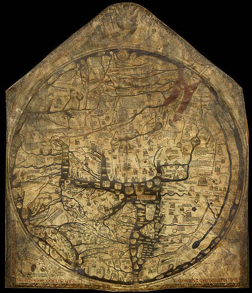
Created around 1300 CE, the Hereford Mappa Mundi is the largest medieval map known to still exist. Housed in Hereford Cathedral in England, it measures 1.58 by 1.34 meters and is drawn on a single sheet of vellum. It depicts the world as a circular disc, with Jerusalem at its center, following the medieval Christian tradition. It includes Europe, Asia, and Africa, adorned with illustrations of biblical events, mythical creatures, and various landmarks. It serves as a visual representation of the medieval worldview, combining geography, history, and theology. While not geographically accurate by modern standards, it provides valuable insights into the medieval perception of the world. It remains a significant artifact for the study of medieval cartography and cosmology.
Tabula Rogeriana

In 1154 CE, the Arab geographer Muhammad al-Idrisi created the “Tabula Rogeriana,” a detailed world map commissioned by the Norman King Roger II of Sicily. Al-Idrisi’s map was drawn on a silver disc and accompanied by a comprehensive geographical text. It depicted the known world, including Europe, Asia, and parts of Africa, with remarkable accuracy for its time. Notably, it was oriented with the south at the top, following the Islamic cartographic tradition. He incorporated information from various sources, including travelers and earlier geographers, to create a synthesis of contemporary geographical knowledge. It remained one of the most accurate world maps for several centuries and was widely used by explorers and scholars. Its detailed representation of the Mediterranean and surrounding regions provided valuable insights into medieval geography.
Ptolemy’s World Map

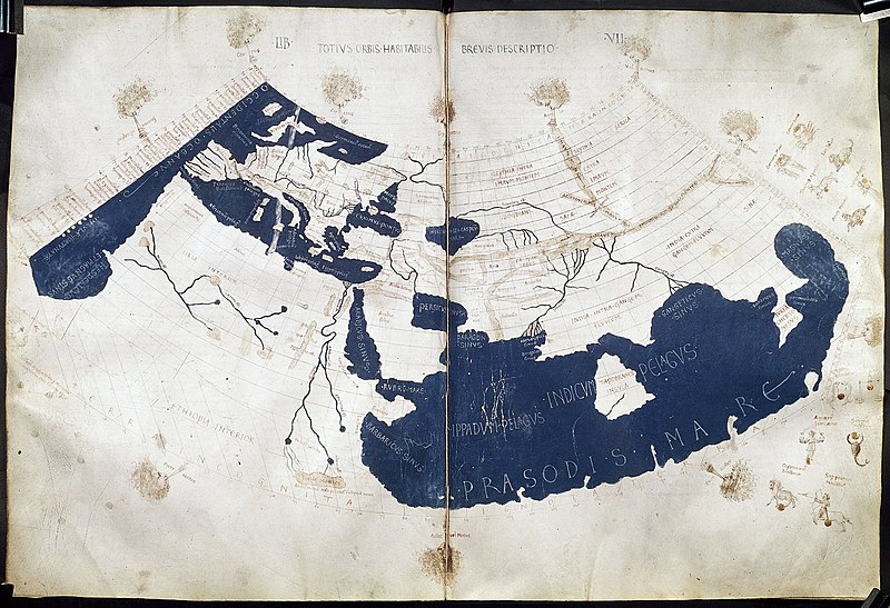
Claudius Ptolemy, a Greco-Roman mathematician, astronomer, and geographer, compiled a comprehensive world map in the 2nd century CE, documented in his work “Geographia.” His map was based on a compilation of the knowledge of the Roman Empire and beyond, utilizing a coordinate system of latitude and longitude. He employed a conic projection to represent the spherical Earth on a flat surface, a method that influenced cartography for centuries. The map depicted the known world, including Europe, Asia, and Africa, extending as far east as China and as far south as the Horn of Africa. His work was rediscovered in the Renaissance, profoundly impacting the development of modern cartography. His emphasis on mathematical precision and the use of a grid system set new standards for mapmaking. While the original maps have not survived, numerous manuscripts and printed editions from the 15th century onward have preserved his cartographic legacy.
Turin Papyrus Map

The Turin Papyrus Map, created around 1160 BCE, is often regarded as the oldest known topographical map. Originating in ancient Egypt, it was crafted during the reign of Pharaoh Ramesses IV by an Egyptian scribe named Amennakhte. The map, drawn on papyrus, depicts the Wadi Hammamat region, a site rich in gold and quarry stones. It was designed to guide expeditions and document the area’s geology, showing the location of gold mines, stone quarries, and settlements. It includes labels for various features, written in hieratic script, and even highlights the quality of resources found in different locations. Unlike symbolic maps from later periods, it provides a practical, functional representation of a specific area. Now housed in the Museo Egizio in Turin, it remains a significant artifact for understanding the practical applications of cartography in ancient civilizations. Its precision and utilitarian purpose mark a unique development in early mapping techniques.
Eratosthenes’ World Map

Eratosthenes of Cyrene, a Greek mathematician, geographer, and astronomer, created a world map in the 3rd century BCE that incorporated his groundbreaking calculation of the Earth’s circumference. Serving as the chief librarian at the Library of Alexandria, he utilized the extensive resources available to him. His map divided the world into five climate zones: two frigid zones at the poles, two temperate zones, and a torrid zone at the equator. He introduced a grid system of latitude and longitude, enhancing the precision of geographical locations. His map included the known parts of Europe, Asia, and Africa, extending as far east as India. His work represented a significant advancement in cartography, combining mathematical principles with geographical knowledge. His methodologies influenced later geographers, including Ptolemy, and his concepts remain foundational in modern geography.
Hecataeus of Miletus’ World Map

In the early 5th century BCE, Hecataeus of Miletus, a Greek historian and geographer, produced a world map that expanded upon the work of his predecessor, Anaximander. Although the original map has not survived, it is known through descriptions and later reconstructions. His map depicted the known world as a circular disc, with the Mediterranean Sea at its center, encompassing parts of Europe, Asia, and Libya (Africa). He divided the world into two continents, Europe and Asia, separated by the Mediterranean and the Nile River. This map was accompanied by his work “Ges Periodos” (“Travels Around the Earth”), which provided detailed descriptions of the regions and peoples. His contributions were significant in moving Greek cartography towards a more systematic and empirical approach. His efforts laid the groundwork for future geographers, influencing the development of more accurate maps in subsequent centuries.
Anaximander’s World Map

Anaximander of Miletus, a pre-Socratic Greek philosopher, is credited with creating one of the earliest known world maps in the 6th century BCE. Although the original map has not survived, historical accounts suggest it depicted the known world as a circular form, with Greece at the center. It likely included parts of Europe, Asia, and Libya (the term used for Africa at the time), surrounded by an ocean. His work marked a significant departure from mythological interpretations of the world, introducing a more empirical approach. His map was revolutionary for its time, as it attempted to define the world’s geography based on observation rather than legend. Later Greek cartographers, including Hecataeus of Miletus, refined his ideas, building on his groundwork. While the map itself is lost, its influence on ancient geography and subsequent mapmaking cannot be overstated.
Babylonian Map of the World

Dating back to the 6th century BCE, the Babylonian Map of the World, also known as the “Imago Mundi,” is considered the oldest surviving world map. Originating from ancient Babylon, in present-day Iraq, its creator remains unknown. It is inscribed on a clay tablet using cuneiform script and portrays a circular representation of the known world, with Babylon centrally located. Surrounding Babylon are various regions and cities, all encircled by a “bitter river,” symbolizing the ocean. It also includes descriptions of mythical lands and creatures beyond the known world, reflecting the Babylonian cosmological views. Currently, this artifact is housed in the British Museum, offering a glimpse into the ancient Mesopotamian worldview. The tablet’s reverse side contains additional cuneiform text elaborating on the regions depicted and their significance.
This article originally appeared on Rarest.org.
More from Rarest.org
18 Mysterious Creatures of the World`s Most Isolated Islands

Isolated islands often hide secrets, and some of the world’s most mysterious creatures live in these remote areas. These animals have evolved uniquely, shaped by their environment and isolation. Read More.
21 Strange Geological Formations Found in Uninhabited Lands

The Earth hides some of its most extraordinary formations in uninhabited regions. These remote landscapes are home to geological wonders that seem almost otherworldly. Read More.
16 Elusive Big Cats That Roam the World`s Densest Jungles

The world’s jungles are home to some of the most elusive and mysterious big cats. These majestic creatures often hide in the shadows, making them difficult to spot even in the densest of forests. Read More.
