Exploring the world through the eyes of ancient cartographers reveals a fascinating blend of art, science, and history. Rare antique maps not only depict the geographical knowledge of their time but also offer insights into the cultures, beliefs, and ambitions of their creators. From medieval mappa mundi to detailed navigational charts, these maps tell stories of exploration, discovery, and the ever-evolving understanding of our world. This collection of 18 rare antique maps showcases the remarkable craftsmanship and historical significance of these invaluable artifacts.
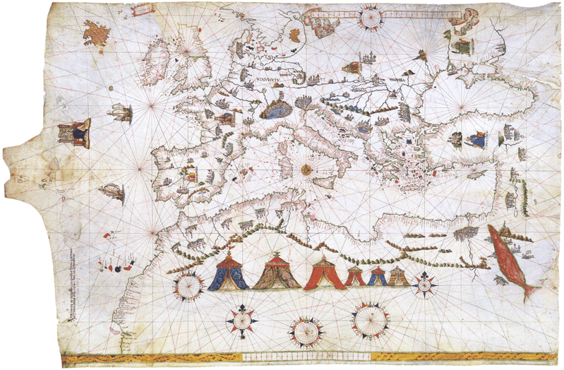
The Piri Reis Map (1513)
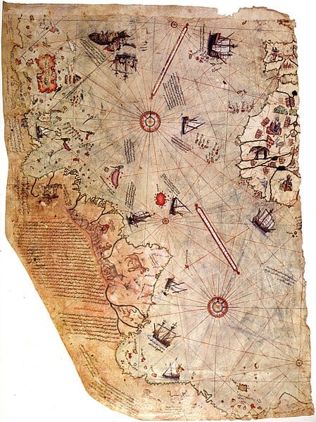
Piri Reis/ Wikimedia Commons
The Piri Reis Map, drawn by the Ottoman admiral and cartographer Piri Reis, is a fragment of a world map. This map is famous for its detailed depiction of the western coastlines of Europe, North Africa, and Brazil. Notably, it also includes parts of the Caribbean and the Atlantic Ocean, displaying an impressive level of detail for its time. Despite its fragmentary nature, the map has sparked numerous theories regarding ancient exploration and the extent of knowledge about the Americas before Columbus.
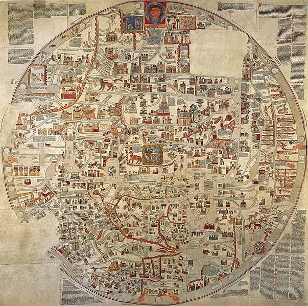
The Hereford Mappa Mundi (c. 1300)
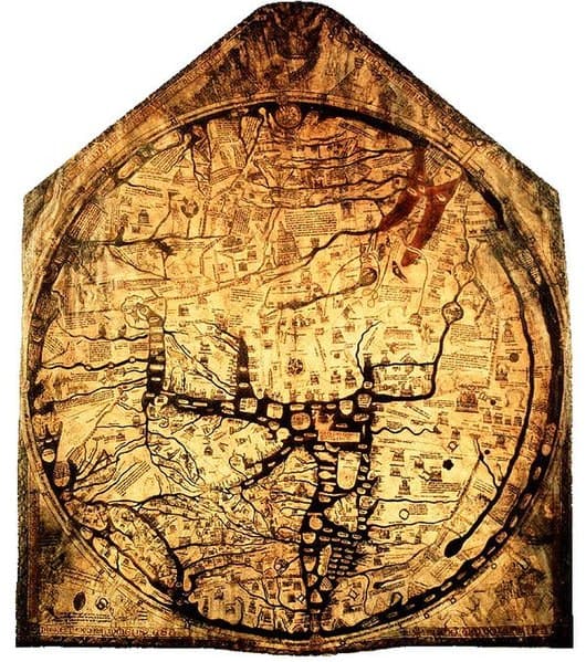
Housed in Hereford Cathedral, England, the Hereford Mappa Mundi is a medieval map depicting the known world. This map, measuring 1.58 by 1.34 meters, includes Jerusalem at its center, symbolizing its religious significance. Surrounding it are detailed illustrations of various cities, biblical scenes, and mythical creatures. The map offers a fascinating glimpse into the medieval worldview, where geography, history, and mythology intertwine.
The Tabula Rogeriana (1154)
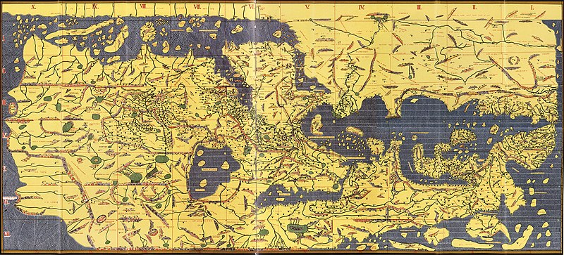
Created by the Muslim scholar Muhammad al-Idrisi, the Tabula Rogeriana was commissioned by the Norman King Roger II of Sicily. This map is a remarkable example of medieval Islamic cartography, showing the Eurasian continent and parts of North Africa. The map’s orientation, with the south at the top, reflects the unique perspective of the time. Al-Idrisi’s work, combining rigorous geographical knowledge with detailed descriptions of various regions, was unparalleled in its accuracy and comprehensiveness for centuries.
The Vinland Map (c. 1440)
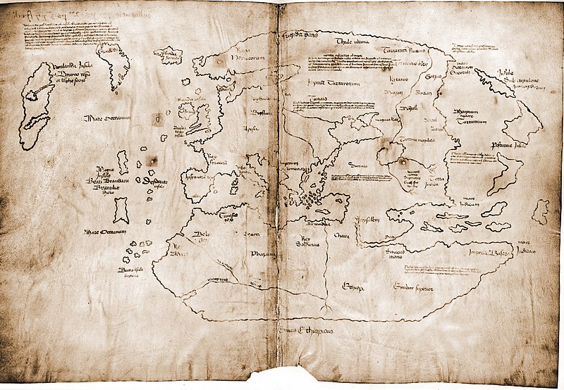
The Vinland Map, purportedly showing parts of North America known as Vinland, is a subject of controversy and intrigue. Allegedly created in the mid-15th century, the map suggests that Norse explorers reached North America long before Columbus. Its authenticity has been debated since its discovery, with some scholars considering it a modern forgery. Nevertheless, it remains a captivating piece for its potential implications on the history of exploration.
The Peutinger Table (c. 4th Century)
The Peutinger Table, or Tabula Peutingeriana, is a unique Roman map depicting the road network of the Roman Empire. This elongated parchment scroll, about 6.75 meters long, highlights the importance of connectivity and infrastructure in ancient Rome. The map stretches from Britain in the northwest to India in the southeast, illustrating major cities, road distances, and notable landmarks. It provides valuable insights into the Roman world and their approach to mapping and travel.
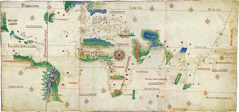
The Cantino Planisphere (1502)
Named after Alberto Cantino, who smuggled it from Portugal to Italy, the Cantino Planisphere is one of the earliest surviving maps showing the discoveries of Portuguese explorers. It details the coasts of Africa, India, and Brazil, reflecting the emerging global perspective of the Age of Discovery. The map’s accuracy in depicting newly explored territories underscores the advanced cartographic skills of its time.
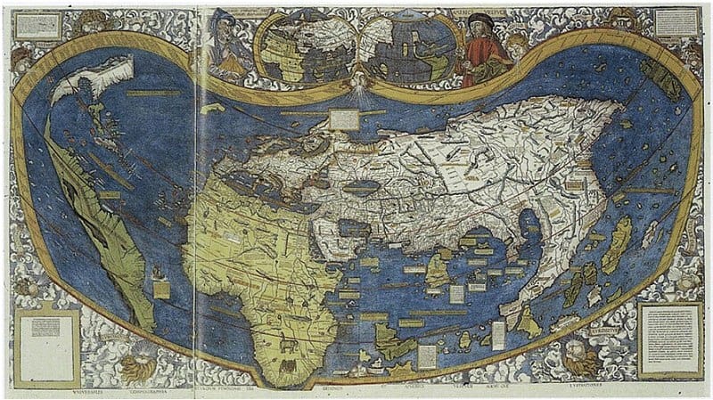
The Waldseemüller Map (1507)
The Waldseemüller Map is renowned for being the first map to use the name “America,” in honor of Amerigo Vespucci. Created by the German cartographer Martin Waldseemüller, this map offers a remarkably accurate representation of the New World for its time. It reflects the rapidly expanding geographical knowledge following the voyages of Columbus and Vespucci, marking a pivotal moment in cartography.
The Ebstorf Map (c. 1234)
The Ebstorf Map, a medieval mappa mundi, was tragically destroyed during World War II, but its detailed photographic records remain. This circular map, centered on Jerusalem, measures over three meters in diameter. It combines geographical knowledge with religious and historical symbolism, depicting biblical events, exotic animals, and various peoples of the world. Its intricate artistry and comprehensive scope make it a valuable artifact of medieval thought.
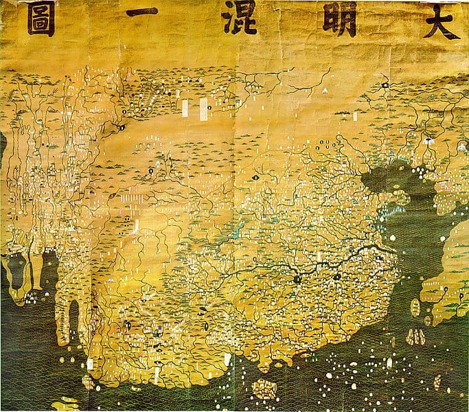
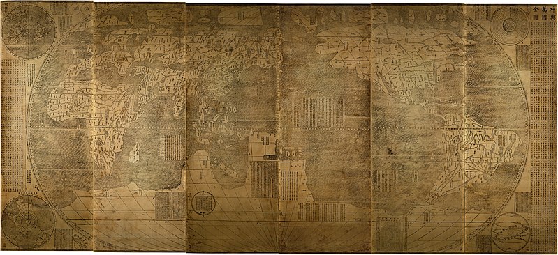
The Da Ming Hun Yi Tu (1389)
The Da Ming Hun Yi Tu, also known as the Amalgamated Map of the Ming Empire, is a Chinese world map from the early Ming Dynasty. It represents an impressive synthesis of Chinese and Western cartographic knowledge, showcasing the extent of the Ming Empire’s geographical understanding. The map covers vast regions from Europe and Africa to East Asia, reflecting the interconnectedness of medieval global trade and exploration.
The Fra Mauro Map (c. 1450)
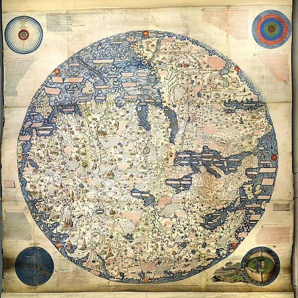
The Fra Mauro Map, created by the Venetian monk Fra Mauro, is a detailed world map notable for its modernity and accuracy. It depicts Europe, Asia, and Africa with remarkable precision, incorporating information from travelers, merchants, and explorers. The map’s orientation, with the south at the top, and its emphasis on practical geographical knowledge make it a significant departure from earlier medieval maps.
The Catalan Atlas (1375)
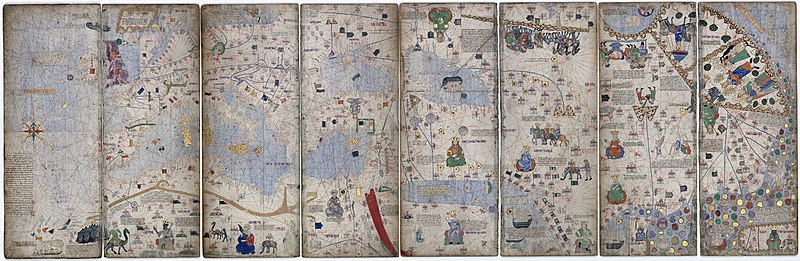
The Catalan Atlas, attributed to the Majorcan cartographer Abraham Cresques, is one of the most beautiful medieval maps. This illuminated manuscript map, created for the King of France, combines detailed geographical knowledge with rich illustrations of cities, peoples, and mythical creatures. It reflects the extensive maritime knowledge of the Catalan traders and explorers, covering Europe, Africa, and Asia.
The John Speed Map of the British Isles (1611)
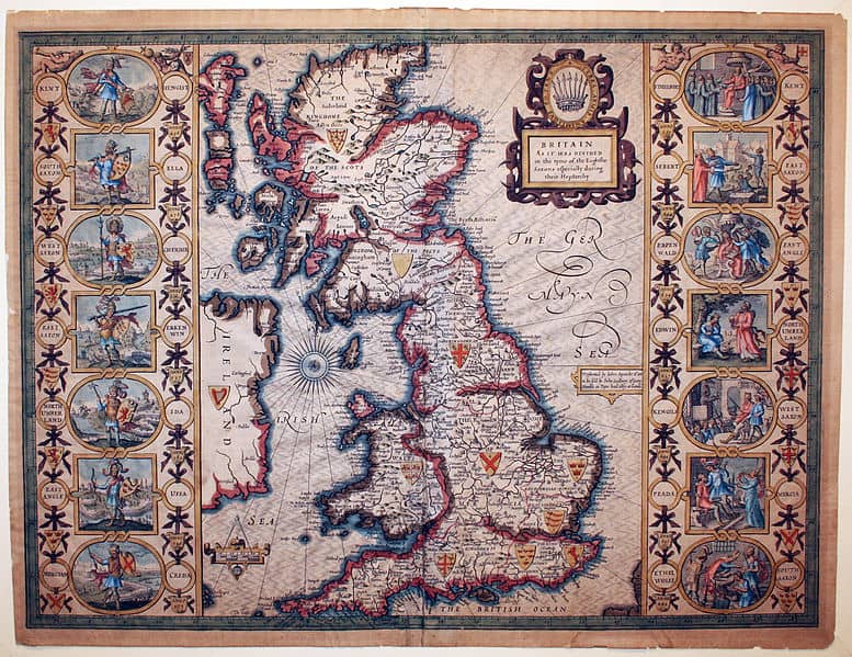
John Speed’s map of the British Isles, part of his groundbreaking atlas “The Theatre of the Empire of Great Britaine,” is a masterpiece of early modern cartography. This map is celebrated for its detailed depiction of England, Scotland, Ireland, and Wales, along with insets of major cities. Speed’s work combines geographical accuracy with elaborate artistry, setting a new standard for mapmaking in the 17th century.
The Map of Tenochtitlan (1524)
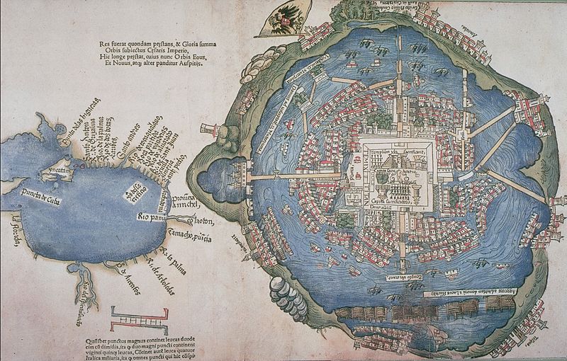
The Map of Tenochtitlan, created by the Spanish conquistadors, offers a rare glimpse into the Aztec capital before its destruction. This map, included in Hernán Cortés’s second letter to Charles V, depicts the intricate layout of Tenochtitlan, showcasing its impressive architecture, causeways, and canals. It provides valuable insights into the urban planning and sophistication of the Aztec civilization.
The Kunyu Wanguo Quantu (1602)
The Kunyu Wanguo Quantu, or “Map of the Ten Thousand Countries of the World,” was created by the Jesuit missionary Matteo Ricci in China. This map, the first Chinese world map incorporating European geographical knowledge, reflects a fusion of Eastern and Western cartographic traditions. It introduced Chinese scholars to the concept of a spherical Earth and global geography, marking a significant cultural exchange.
The Gough Map (c. 1360)
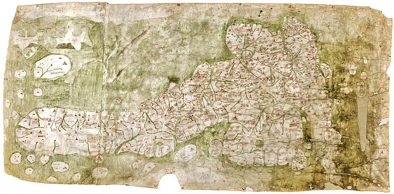
Image Editorial Credit: Bodleian Libraries/ Wikimedia Commons
.jpg)
The Gough Map, named after its 19th-century owner Richard Gough, is one of the earliest surviving maps of Great Britain. This medieval map offers a surprisingly accurate representation of the British Isles, highlighting major towns, rivers, and roads. Its detailed depiction of the English landscape provides invaluable insights into medieval geography and travel.
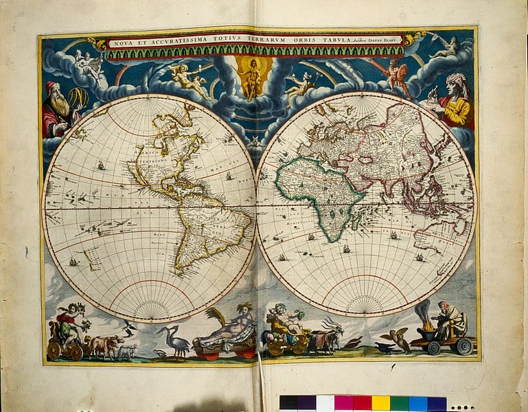
The Nova Totius Terrarum Orbis Tabula (1648)
Created by the Dutch cartographer Joan Blaeu, the Nova Totius Terrarum Orbis Tabula is a stunning example of 17th-century Dutch mapmaking. This world map, adorned with elaborate illustrations and cartouches, reflects the height of Dutch cartographic art. It showcases the global reach of Dutch exploration and trade, capturing the world as known to Europeans in the mid-17th century.
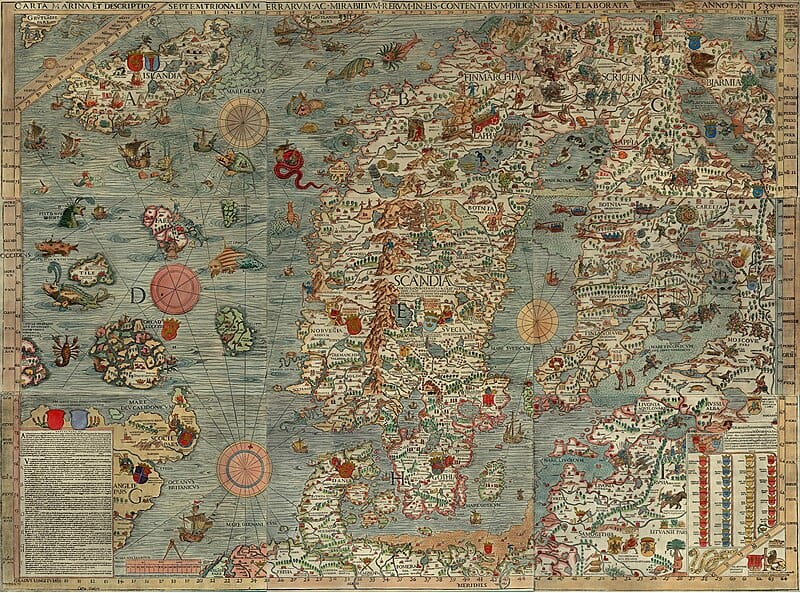
The Carta Marina (1539)
The Carta Marina, created by the Swedish cartographer Olaus Magnus, is the first detailed map of Scandinavia. This map, filled with depictions of sea monsters, ships, and coastal cities, combines geographical accuracy with artistic flair. It provides a vivid picture of Northern Europe during the Renaissance, reflecting both contemporary knowledge and folklore.
The Portolan Charts (13th-17th Century)
Portolan charts, created by medieval and early modern sailors, are some of the most accurate navigational maps of their time. These charts, used for maritime navigation, depict coastlines, ports, and sea routes with remarkable precision. Originating in the Mediterranean, portolan charts evolved over centuries, reflecting advancements in navigation and geographical knowledge.
This article originally appeared on Rarest.org.
More From Rarest.Org

.jpg#mw-jump-to-license)
Primates are among the most fascinating and diverse groups of animals, but many of their species are facing critical threats to their survival. From habitat destruction to illegal hunting, these challenges have pushed some primates to the brink of extinction. Read more.
18 Rarest Mosses Found in High Altitudes

High-altitude environments present some of the most challenging conditions for plant life, yet within these harsh landscapes, a variety of moss species have adapted and thrived. These mosses, often rare and specialized, exhibit unique characteristics and resilience that allow them to survive in extreme conditions such as cold temperatures, high winds, and limited water availability. Read more.
13 Most Elusive Marine Mollusks

The ocean is a vast, mysterious realm, home to some of the most elusive and fascinating creatures on Earth. Among these are marine mollusks, a diverse group of invertebrates that include squids, octopuses, and snails. Read more.