Maps have long been more than just tools for navigation—they are windows into the knowledge, ambitions, and creativity of the people who made them. Some historic maps are so rare that only a handful of copies, or even a single version, survive today. These exceptional artifacts provide valuable insights into how past civilizations understood their world, blending geography, artistry, and imagination. From medieval depictions of mythical lands to revolutionary charts that changed the course of exploration, each map tells its own unique story. Their scarcity makes them priceless links to history, cherished by collectors and historians alike.
Waldseemüller Map (1507)
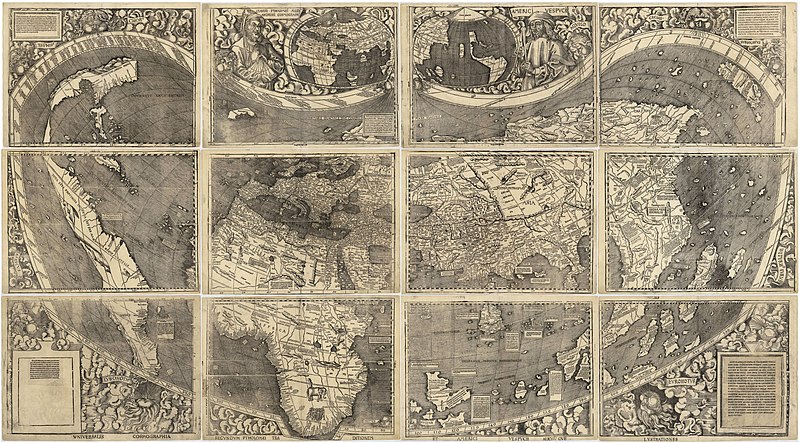
The Waldseemüller Map, often called the “Birth Certificate of America,” is one of the most significant maps in history. Created by German cartographer Martin Waldseemüller, it was the first map to label the New World as “America,” honoring explorer Amerigo Vespucci. This map marked a pivotal shift in geographic understanding during the Age of Exploration. Originally printed in 12 sheets, only one complete copy is known to exist today. It depicts a remarkably modern view of the continents for its time, blending newly discovered lands with ancient geographic theories. The lone surviving copy resides at the Library of Congress, acquired for $10 million in 2003. Its rarity and historical impact make it one of the most valuable cartographic treasures ever produced.
Hereford Mappa Mundi (ca. 1300)
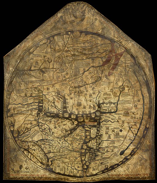
The Hereford Mappa Mundi is a medieval treasure housed in Hereford Cathedral, England. This map is the largest known surviving example of a mappa mundi, a type of medieval world map. Unlike modern maps, it prioritizes spiritual and theological concepts over geographic accuracy. It portrays Jerusalem at the center, with biblical events and mythical creatures scattered across its surface. Made on a single sheet of vellum, it remains an extraordinary example of medieval cartography. Only a few comparable maps from the era have survived, and none match its size or detail. Its intricate artwork and unique perspective continue to fascinate historians and theologians alike.
The Cantino Planisphere (1502)
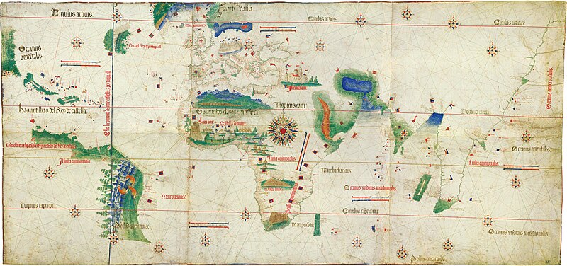
The Cantino Planisphere, one of the earliest surviving maps to show Portuguese discoveries in the New World, is a masterpiece of Renaissance cartography. Named after Alberto Cantino, who smuggled it out of Portugal, the map reflects the nation’s cutting-edge maritime knowledge. Its detailed depiction of Africa, India, and the Americas highlights the global ambitions of 16th-century explorers. Only one copy exists today, housed in the Biblioteca Estense in Modena, Italy. The map is celebrated for its lavish use of color and precision, demonstrating the power of cartography as a geopolitical tool. Its fascinating story of espionage adds to its mystique. It remains an irreplaceable link to the early days of European exploration.
Tabula Peutingeriana (4th–13th Century)
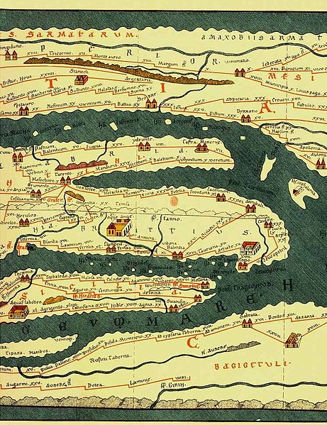
The Tabula Peutingeriana is an ancient Roman road map that captures the sprawling infrastructure of the empire. It consists of a long, scroll-like representation of major Roman roads and cities, stretching from Britain to India. Though originally created in the 4th century, the surviving copy is a medieval reproduction. Preserved in the Austrian National Library, it is the only known version of this invaluable piece of Roman history. Its unique design compresses vast geographic areas into a single, easy-to-read format. The map offers insights into ancient travel and commerce while reflecting the logistical might of the Roman Empire. Its scarcity and historical relevance make it an unparalleled artifact.
Piri Reis Map (1513)

The Piri Reis Map is a fragmentary world map created by the Ottoman admiral and cartographer Piri Reis. It is famous for its remarkably accurate depiction of the Atlantic coastline, including parts of South America and Antarctica. The map has fueled speculation about advanced pre-modern navigation techniques. Only one fragment of the map exists today, preserved at the Topkapi Palace Museum in Istanbul. Drawn on gazelle skin, it combines geographic knowledge from multiple sources, including ancient maps and contemporary explorers. Its blend of artistry and precision makes it a subject of enduring intrigue. The map’s mysterious origins and advanced detail continue to captivate historians and enthusiasts.
Vinland Map (ca. 15th Century)
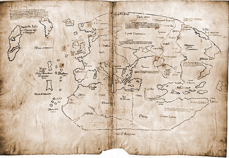
The Vinland Map claims to show a part of North America discovered by Norse explorers long before Columbus. Allegedly created in the 15th century, it includes a mysterious landmass labeled “Vinland,” thought to be modern-day Newfoundland. Controversy surrounds its authenticity, with debates about whether it’s a genuine artifact or a clever forgery. Housed at Yale University, this map remains one of the rarest and most debated artifacts in cartographic history. Its delicate parchment and faded ink add to its enigmatic appeal. Regardless of its origins, it has sparked global interest in Viking exploration. Its rarity ensures its place as a treasured, if contentious, historical document.
The Fra Mauro Map (ca. 1450)
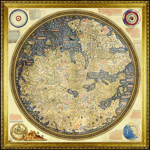
The Fra Mauro Map is a circular world map created by Venetian monk Fra Mauro. Known for its meticulous detail and groundbreaking depiction of the Old World, it was created during the height of the Renaissance. The map is celebrated for its inclusion of geographic information gathered from explorers, merchants, and travelers. Only one copy, held at the Biblioteca Nazionale Marciana in Venice, survives today. Fra Mauro’s work challenges the Eurocentric perspectives of his time, placing Asia and Africa at the forefront of his map. Its artistic flourishes and detailed annotations make it a visual masterpiece. As a synthesis of medieval and Renaissance cartography, it stands out as an invaluable historic artifact.
The Psalter Map (ca. 1260)
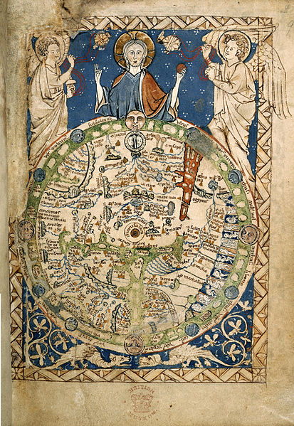
The Psalter Map, a small yet ornate mappa mundi, reflects the medieval worldview centered around Christianity. This map, roughly the size of a modern sheet of paper, places Jerusalem at its heart, symbolizing the spiritual focus of medieval life. Its intricate illustrations depict biblical events, legendary creatures, and imagined geography. Only one copy is known to exist, kept in the British Library. Despite its small size, the map’s craftsmanship and theological importance are unparalleled. Its scarcity underscores the fragility of medieval cartographic works. Today, it provides a unique window into the intersection of art, faith, and geography in the Middle Ages.
Carta Marina (1539)
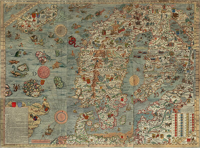
The Carta Marina, created by Swedish cartographer Olaus Magnus, is a richly illustrated map of Scandinavia and surrounding regions. Known for its stunning detail, it includes depictions of mythical sea monsters and vignettes of Nordic life. Only two copies of this extraordinary map survive, one in the Uppsala University Library and the other in the Bavarian State Library. Its large size and vibrant illustrations make it both a geographic and artistic masterpiece. This map reflects Magnus’s efforts to combine accurate geographic knowledge with folklore and storytelling. The inclusion of detailed coastlines and historical annotations distinguishes it from other Renaissance maps. Its rarity and artistic merit have cemented its status as a priceless historical artifact.
John Speed’s Map of New England and New York (1676)

This map, created by renowned English cartographer John Speed, is one of the first detailed depictions of the northeastern United States. It shows early settlements, rivers, and indigenous territories with remarkable precision for its time. Only a handful of original copies are known to exist, each considered a valuable glimpse into the colonial era. The map is notable for its inclusion of both English and Dutch settlements, reflecting the region’s contested history. Its decorative elements, such as coats of arms and elaborate borders, add to its historical allure. Currently housed in select archives and private collections, its scarcity makes it a sought-after collector’s item. As a visual record of early American history, it holds immense cultural and historical significance.
The Gough Map (ca. 1360)
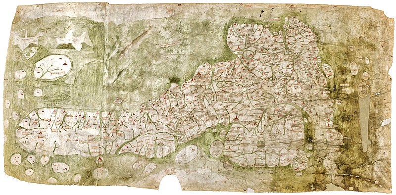
The Gough Map is one of the oldest surviving maps to depict Great Britain with a recognizable geographic form. It provides an invaluable look at medieval England, showing roads, towns, and rivers with surprising accuracy for its time. The map takes its name from Richard Gough, an antiquarian who donated it to the Bodleian Library, where it remains today. Its unique combination of geographic detail and medieval artistic style makes it a rare treasure. Scholars have used it to understand trade routes and travel during the 14th century. Despite its fragile condition, the map offers a vivid portrayal of medieval cartographic ingenuity. Few maps from this era have survived, making the Gough Map an irreplaceable artifact.
The Mercator World Map (1569)
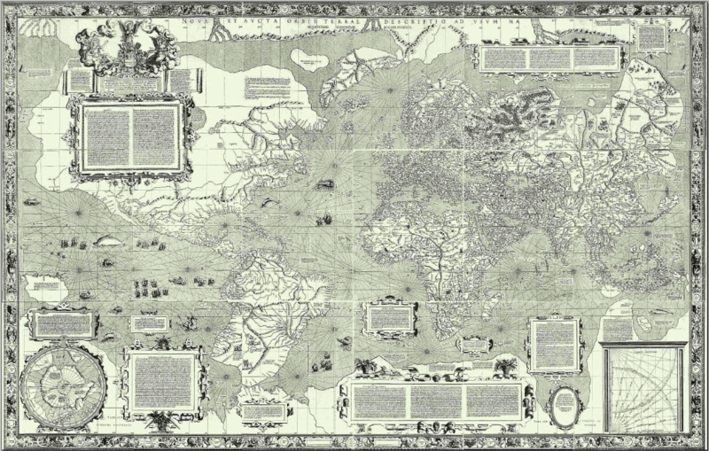
Gerardus Mercator’s 1569 world map introduced the revolutionary Mercator projection, still widely used in navigation today. This map provided sailors with an accurate means of plotting a course, despite distorting the size of landmasses near the poles. Only three copies of this groundbreaking map are known to exist, held in private collections and institutions. The map’s detailed engraving and inclusion of new discoveries, such as parts of the Americas, showcase Mercator’s genius. Its intricate borders and annotations reflect the artistic and intellectual spirit of the Renaissance. Beyond its navigational use, it represents a shift toward modern cartography. Its historical and scientific significance make it one of the most important maps ever created.
The Turin Papyrus Map (ca. 1150 BCE)
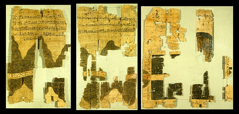
The Turin Papyrus Map is the oldest known map of a mining region, created during the reign of Pharaoh Ramesses IV in ancient Egypt. It depicts a section of the Eastern Desert, illustrating the location of gold and stone quarries. The map is made of fragile papyrus and is housed in the Egyptian Museum in Turin, Italy. Its precise measurements and annotations demonstrate the advanced cartographic skills of ancient Egyptian surveyors. This map is unique for its practical purpose, as it was used for mining expeditions rather than exploration. Its age and historical context make it one of the rarest cartographic artifacts. Scholars continue to study it for insights into ancient engineering and resource management.
Zeno Map (ca. 1558)
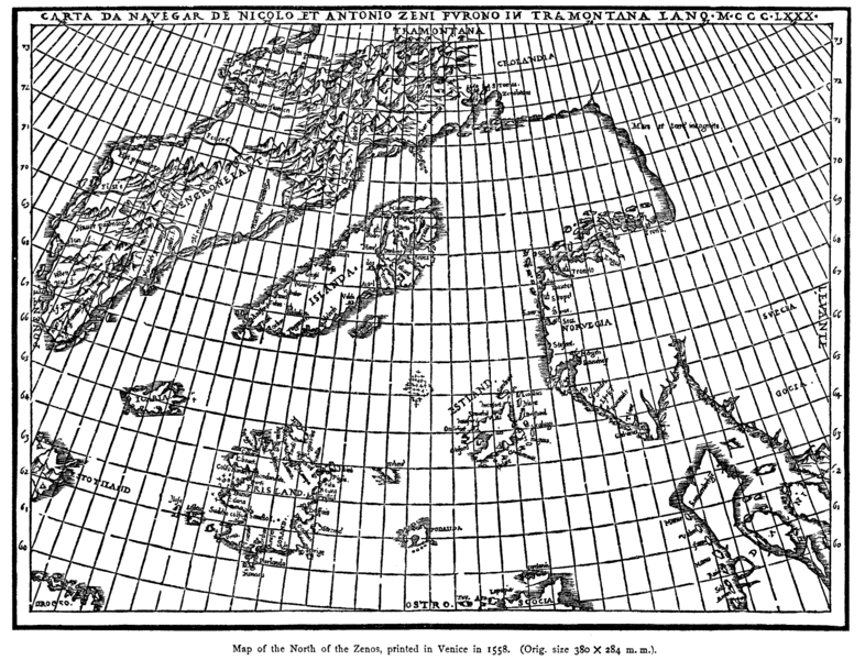
The Zeno Map, attributed to the Venetian Zeno brothers, presents a fascinating depiction of the North Atlantic, including Greenland and the mythical island of Frisland. Though its authenticity has been debated, it influenced explorers like John Cabot and Christopher Columbus. Only one copy exists, held in a private collection, making it one of the rarest maps from the Age of Exploration. The map’s inclusion of fictional elements highlights the blend of myth and knowledge in early cartography. Despite its questionable accuracy, it provides a snapshot of 16th-century geographic imagination. Its elaborate illustrations and annotations add to its enigmatic appeal. For historians, it serves as both a cartographic and cultural curiosity.
Buondelmonti Map (1420)
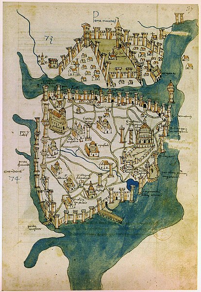
The Buondelmonti Map, created by Italian monk Cristoforo Buondelmonti, is one of the first maps to accurately depict the Aegean Sea and its islands. This map, part of his book Liber Insularum Archipelagi, was revolutionary for its detailed representation of the Mediterranean world. Only a few copies survive today, one of which is preserved in the Laurentian Library in Florence. Unlike medieval mappa mundi, it focuses on geographic accuracy rather than spiritual symbolism. Its hand-painted illustrations of islands and coastlines highlight the growing interest in navigation during the Renaissance. The map was widely used by travelers and traders in the Mediterranean region. Its rarity and influence make it a cornerstone of early modern cartography.
De Virga World Map (1411–1415)
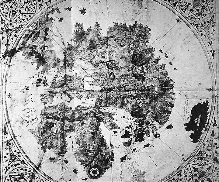
The De Virga World Map, created by Venetian cartographer Albertinus de Virga, is a circular map showing Europe, Asia, and Africa with astonishing precision for its time. The map also includes a mysterious landmass in the southern hemisphere, possibly reflecting early speculative geography. Only one copy exists, and its current location remains unknown after being last documented in a private collection in the 20th century. Its intricate details and inclusion of mythical features, such as the Garden of Eden, demonstrate a blend of knowledge and imagination. De Virga’s map is particularly notable for its early use of longitude and latitude lines. Its disappearance has added an air of mystery, making it a prized piece of lost cartographic history. Despite its elusive nature, its influence on subsequent maps is undeniable.
The Carta Pisana (ca. 1275)
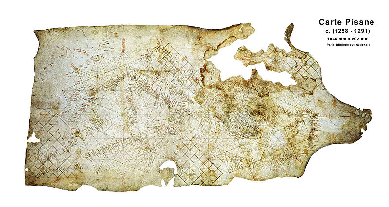
The Carta Pisana is one of the earliest surviving portolan charts, representing a turning point in medieval navigation. Likely created in Pisa, Italy, this map depicts the Mediterranean Sea with extraordinary accuracy, emphasizing coastal features for sailors. Only one copy survives, held in the Bibliothèque Nationale de France in Paris. Its detailed network of compass lines and place names reflects the advanced maritime knowledge of the 13th century. Unlike earlier symbolic maps, the Carta Pisana prioritizes practicality, marking a shift toward modern cartography. The map’s craftsmanship and functionality made it a vital tool for Mediterranean mariners. Its survival offers invaluable insights into medieval navigation techniques and trade.
The Ebstorf Map (ca. 1234)
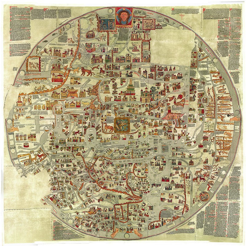
The Ebstorf Map, a large circular mappa mundi, depicted the world according to medieval Christian theology. It was housed in Ebstorf Abbey in Germany until it was destroyed during World War II. Thankfully, black-and-white reproductions survive, preserving its unique representation of the world with Jerusalem at the center. The map featured elaborate illustrations of biblical events, mythical creatures, and historical landmarks. Its massive size and intricate detail made it one of the largest and most comprehensive mappa mundi ever created. Scholars regard it as a vital resource for understanding medieval European worldviews. Although only reproductions remain, its influence endures in the study of medieval cartography.
This article originally appeared on Rarest.org.
More From Rarest.Org
Vintage kitchenware has become more than just nostalgic decor; many pieces are now surprisingly valuable collectibles. Items like cast iron skillets, Pyrex mixing bowls, and jadeite glassware are not only beautiful but often crafted with a level of quality that’s hard to find in modern counterparts. Read more.
The world’s population is growing rapidly, and some countries are leading the way in size. Nations with the largest populations often face unique challenges and opportunities. Their large populations also impact global economies and politics. Read more.

Solar farms have rapidly emerged as powerful contributors to the global shift toward renewable energy, harnessing the sun’s abundant power to generate clean electricity on an unprecedented scale. These massive installations, often spanning thousands of acres, produce enough energy to power entire cities, highlighting the incredible potential of solar technology in tackling climate change. Read more.

